Site + Program Research
Part of the Maryhill Loops Road intervention in my thesis: “Constructing the Gestalt”
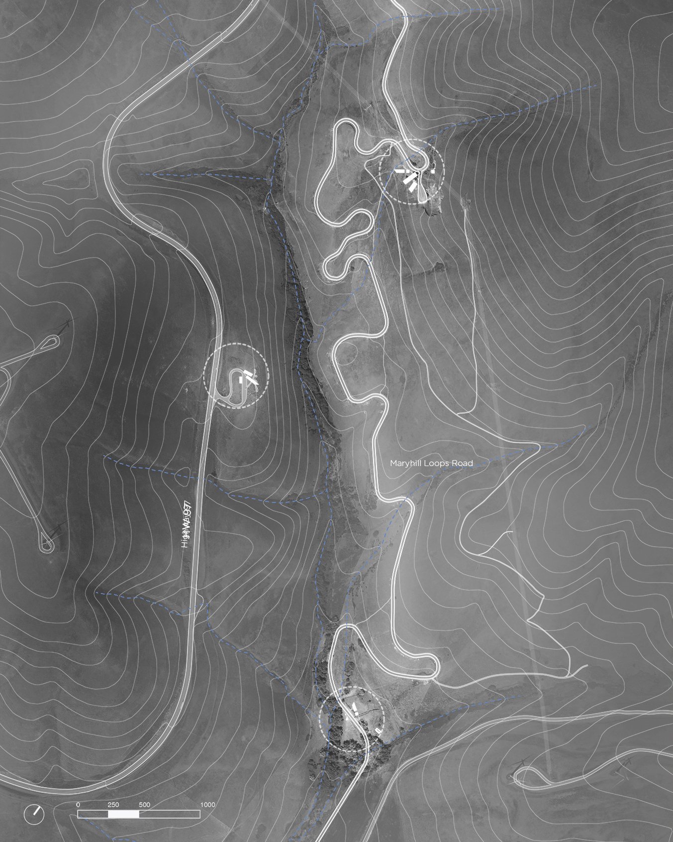
History of Maryhill Loops Road
Maryhill Loops Road is located in south-central Washington state on the north side of the Columbia river. The Maryhill community was founded by the railroad executive Sam Hill in 1907 and was intended to attract members of the Quaker community to move out west. In 1913 the Maryhill Loops Road was commissioned by Sam Hill and constructed by the landscape architect Samuel C. Lancaster. The road was the first asphalt road in Washington state which used sweeping curves to combat steep grades. Hill also commissioned Lancaster to provide additional infrastructure at the site to accommodate a potential Quaker community. The infrastructure failed within a year and the planning of the community was eventually abandoned.
The road was refurbished in 1998 and is currently owned by the Maryhill Museum of Art. The museum is housed in Sam Hill’s old mansion several miles down the highway and remains active in the coordination of several major events held at the road. Since the road is closed to public motor traffic it has become a favorite spot for downhill-sports enthusiasts. Several events such as ‘Car is King’ and the ‘Maryhill Festival of Speed’ are held at the road annually. The road’s proximity to the town of Goldendale and to I-84 on the Columbia River allows for easy access to the road from other parts of the state. There are currently several houses and cattle corals scattered throughout the landscape with the expansive Windy Point/Windy Flats wind farm serving as a dramatic backdrop.
Maryhill Loops Road is currently lacking any significant support structures which benefit the regular users or the annual events held at the road. The intervention proposed acts as an extension of the study attempting to create a sense of place across a vast area.

Sam Hill

Sam Lancaster

Maryhill Museum of Art

Longboarders at the Maryhill Festival of Speed

Street luge racer at the Maryhill Fall Free Ride

Road rented out by car enthusiasts
Designing a program
Rather than beginning with a discrete set of elements which would be distributed across the site, a list of functions the intervention must perform was developed. These functions were mapped to potential users from which a program could be written and a gestalt architecture designed.

Maryhill Museum of Art

Program diagram mapping functions with potential users.
Three Areas
The intervention plays out across three areas in the Maryhill Loops Road site. If the objective of the study is to design a framework in which a sense of place may be constructed, an area as opposed to a line needs to be established. The three areas give inhabitants the choice to move between them in whatever order they choose to, as opposed to an orchestrated sequence of moves. As the inhabitants move through the different buildings at each area their experience will result in a slightly different ‘framework of place’. Much like the architecture though, this framework seeks an ‘ideal’ state even though it can never be achieved.
This area is given a prototyping and fabrication laboratory for longboard skateboards and the necessary infrastructure needed to manufacture small batches of goods. An archive for molds used in the manufacturing process is incorporated into a visitor center that welcomes people to the site. A small pavilion greets visitors and acknowledges the start of the road. Finally, a lookout point engages the diverse topography of the site allowing views out to the surrounding landscape and wind farm.
Enhancements to an existing overlook point are proposed to create a destination along Highway 97. A small restaurant, overlook platform and restroom facility bring new function and purpose to the area while also engaging Maryhill Loops Road from a completely different vantage point.
The final area acts as a terminus for events held at Maryhill Loops Road and a destination for visitors in the area. An observation tower gives the area an element which attempts to create a visual relationship to the other sites. A small restroom facility and pavilion enhances the site’s ability to hold large crowds that gather at the bottom of the road during events.


The site is divided up into sections using guiding lines which pinpoint key intersections on the site. Conceiving of the site as a series of outdoor rooms sets up a relationship between existing conditions and the architectural intervention.

Rockite site model studying the effects of dividing the site in intervals that enclose the boundary of the road relative to the landscape.
© Forrest Bibeau, 2022